
In the dynamic world of photography, a multitude of techniques are employed to capture moments, create art, and narrate stories. Among these techniques, ground vs. aerial photography are two prominent methods of vertical photographs, each providing a unique viewpoint and offering its own set of advantages and challenges.
Ground photography is the traditional form of capturing images, where the photographer operates the camera at ground level. This traditional approach includes a vast range of photography genres, from still photos of the sweeping landscapes to intimate portraits, and even to the detailed world of macro photography. Its versatility, accessibility, and capacity to produce high-quality images have solidified its status as a cornerstone in the realm of photography.
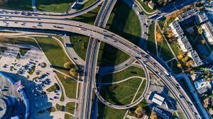
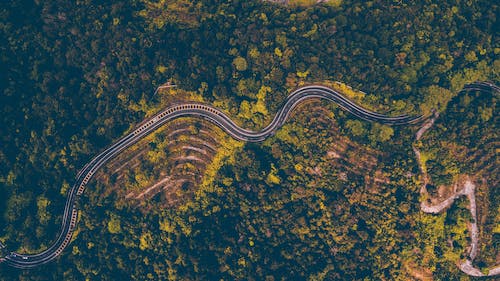
On the other end of the spectrum is aerial photography, a method that drastically changes perspective by capturing images from an elevated position. These bird’s eye view aerial photographs can be captured using various means, including drones, helicopters, kites, and high towers. Aerial photography provides a unique perspective that can deliver striking images unachievable from the ground, transforming ordinary scenes into extraordinary views.
Historically, the art and science of photography have captivated us since the early 19th century, with ground photography naturally being the first and most common form due to technological constraints. Conversely, aerial photography had its genesis during the same century, with early pioneers using balloons to gain a higher vantage point. The technique gained prominence in the 20th century, especially during the World Wars, where it was used extensively for reconnaissance purposes. The advent of drone technology in recent years has ushered in a new era for aerial photography, democratizing its access to professionals and hobbyists alike.
What to Look for in this Article
In this article, we delve into a detailed comparison of ground versus aerial photography. We’ll explore their individual strengths and weaknesses, and consider the contexts where one might be favored over the other. So whether you’re a seasoned professional, a passionate hobbyist, or simply curious about the world of photography, read on to gain a fresh perspective on these two fascinating photographic techniques.
Ground Photography

Ground photography is a broad term that encompasses most of the traditional forms of photography we’re familiar with today. As the name suggests, it involves capturing images while the photographer is at or near ground level. Ground photography can involve a wide array of subjects and scenes, from a vast, breathtaking landscape photograph to the intricate details of a macro shot. It also includes portrait, wildlife, street, architectural, and many other types of photography.
Techniques involved in Ground Photography:
In ground photography, techniques can vary significantly based on the type of photo being captured. For instance, landscape photography often involves using a smaller aperture to create a larger depth of field, allowing both the foreground and background to be in focus. Meanwhile, portrait photography might use a larger aperture to create a shallow depth of field, keeping the subject in focus while blurring the background. Other techniques such as long exposure for night shots or astrophotography, or the use of filters for managing light and reflections, are also commonly used.
Equipment required in Ground Photography:
The equipment used in ground photography is versatile and can range from simple to complex based on the photographer’s needs and style. The basic equipment usually includes a camera (DSLR, mirrorless, or even a smartphone), lenses suited for the genre (wide-angle for landscapes, telephoto for wildlife, prime lenses for portraits), a tripod for stability and long exposure shots, and possibly filters for controlling light. In more specialized forms, such as macro photography, additional equipment like macro lenses and ring flashes might be used. For professionals, equipment may also extend to various types of lighting, backdrops, and props, particularly in studio settings.
Pros of Ground Photography
Following are the pros of ground photography:
Detail and precision in Ground Photography:
One of the most salient advantages of ground photography is the level of detail and precision it affords. With the ability to closely approach the subjects, photographers can capture intricate details, revealing the texture and minutiae that would be impossible from a distance. This close proximity is crucial in certain genres like macro photography, where the beauty often lies in the fine details of small subjects, or in portrait photography, where facial features and expressions are paramount. Furthermore, in architectural and product photography, precision in capturing the geometry and nuances of the subjects plays a key role, and this is best achieved from the ground.
Controlled environment in Ground Photography:
Ground photography often offers the opportunity for a more controlled environment. This is particularly true for studio or indoor photography, where elements such as lighting, background, props, and the positioning of the subject can be manipulated to achieve desired results. This control extends to outdoor settings as well, where photographers can make use of reflectors, diffusers, and artificial lighting to manage shadows and highlights.
Lower cost in Ground Photography:
Generally, ground photography entails a lower cost compared to aerial photography. The basic necessities for ground photography, like a camera and a lens, can range from reasonably affordable to professional-grade expensive. However, when compared to the cost of aerial photos and equipment such as drones, along with their maintenance, licensing, and insurance costs, ground photography is significantly less financially demanding.
Wide variety of subjects in Ground Photography:
Ground photography presents a wide scope for diversity in subjects. From grand landscapes to close-up portraits, from the hustle and bustle of street photography to the calm and control of studio photography, the possibilities are virtually endless. The variety extends beyond genres to the manipulation of elements like light and shadows, the use of different angles, and the creative application of photographic techniques. This versatility allows for rich and varied photographic expression.
Cons of Ground Photography
Following are the cons of ground photography:
Limited perspective in Ground Photography:
While ground photography offers numerous advantages, it does come with its set of limitations, the primary one being perspective. Since photographs are generally taken at eye level, the scope of what you can capture in a single frame of ground photograph is limited. The same scene or subject might look vastly different and perhaps more compelling when viewed from above, which is something ground photography cannot achieve.
Obstructed views in Ground Photography:
Another challenge in ground photography is dealing with obstructed views. Buildings, trees, crowds, and other environmental elements can often get in the way of your subject or landscape, thereby limiting your composition choices. These obstructions can make it difficult to capture clean, uncluttered images in ground photographs, particularly in urban or densely populated settings.
Space limitations in Ground Photography:
Ground photography is also often limited by space constraints. In tight or enclosed spaces, it can be difficult to capture the full breadth of the scene, even with a wide-angle lens. Similarly, in vast landscapes, it may not be possible to convey the grandeur or the scale from ground level. These spatial constraints can limit the ability of vertical aerial photographs to fully express the scene or subject’s scope and context.
Aerial Photography

Aerial photography introduces a new dimension to image capturing by elevating the camera axis and the viewpoint above the ground level. This approach offers unique perspectives and allows for the coverage of large areas within a single frame. Aerial photography is widely used across various sectors, including real estate, surveying, construction, environmental studies, and even in creative and journalistic fields.
Techniques involved in Aerial Photography:
Aerial photography demands a different set of techniques compared to ground photography. Firstly, understanding how to operate a flying device (like a drone) is essential. Piloting skills are needed to position the camera correctly and safely. A good sense of composition is also important as the elevated viewpoint can change how elements align within the frame. Other techniques involve planning the flight path, managing the camera settings remotely, and sometimes stitching multiple images together for panoramic views or large-scale maps. For optimal lighting, many aerial photographers prefer shooting during the “golden hour,” the period shortly after sunrise or before sunset, when the light can add depth and richness to the photographs.
Equipment required in Aerial Photography:
The most common equipment used for aerial photography today is drones, also known as Unmanned Aerial Vehicles (UAVs). Drones range from relatively inexpensive models for beginners to more advanced drones for professional use, equipped with high-resolution cameras and advanced flight features. Some drones also allow for the mounting of professional DSLR or mirrorless cameras for even higher image quality. In addition to the drone and camera, other equipment includes remote controllers, spare batteries, and often a software or app for flight control and image capture. For higher altitude or large-scale aerial photography, manned aircraft such as helicopters or small airplanes may be used.
Pros of Aerial Photography
Following are the pros of aerial photographs
Unique perspectives in Aerial Photography:
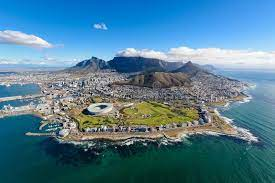
One of the striking benefits of aerial photography is the unique perspectives it provides. It’s all about the bird’s eye view – the ability to view landscapes, structures, and events from an elevated perspective can drastically change the perceived aesthetics and reveal unseen patterns, shapes, and relationships. This shift in viewpoint can transform ordinary scenes into captivating and intriguing photographs, providing fresh insights into familiar subjects. Whether it’s the geometrical patterns of farmland, the sweep of a coastline, or the layout of a bustling city, aerial photography can offer extraordinary visuals that ground photography may not be able to capture.
Large scale coverage in Aerial Photography:
Aerial photography stands out for its ability to cover large scales in a whole area covered by a single frame. This broad coverage is invaluable in several fields. Real estate professionals can showcase the entire property and surrounding areas using topographical maps, urban planners can evaluate land use and growth, environmental scientists can assess the health of ecosystems, and archaeologists can discover hidden structures or features. This large-scale coverage by aerial images provides a holistic picture that is often crucial for various types of analysis, documentation, and presentation.
Unobstructed views in Aerial Photography:
Another advantage of aerial photography is the potential for unobstructed views. Unlike ground photography, where views can be blocked by buildings, trees, or other obstacles, aerial photography provides clear, unrestricted views of the subject. This unobstructed viewpoint can be especially beneficial for architectural photography, event photography, and any situation where a clear view of the ground features or the entire subject or scene is desired.
Cons of Aerial Photography
Following are the cons of aerial photography
Higher cost in Aerial Photography:
One of the main constraints of aerial photography is the significant financial investment involved. Quality drones, the primary tool for modern aerial photography, can range from a few hundred to several thousand dollars, depending on the specifications and features. High-end models that accommodate professional-grade cameras and lenses for superior image quality are especially costly. Moreover, additional expenses related to aerial photography include maintenance costs, potential repair costs, insurance, and battery replacements. Also, accessories like additional lenses, filters, and cases add up to the overall cost. As such, the initial investment and the upkeep for aerial photography can be substantially higher than traditional ground photography.
Weather dependency in Aerial Photography:
Aerial photography is largely dependent on weather conditions. Adverse weather, such as heavy wind, rain, or snow, can prevent drone flights or result in poor image quality. Drones are particularly susceptible to wind, which can destabilize them and make it difficult to capture steady, clear images. Overcast conditions can lead to dull, flat lighting, while overly bright sunlight can cause harsh shadows and overexposed shots. Thus, aerial photographers need to plan their shoots around the weather and may face delays or cancellations due to unpredictable weather changes.
Technical complexity in Aerial Photography:
Aerial photography involves a significant amount of technical know-how. Piloting drones requires learning and mastering the control systems, which can be complex and time-consuming for beginners. Aside from the flying skills, understanding how to manipulate the camera settings from a distance, how to compose effectively from an aerial photo perspective, and how to handle the technical aspects of data storage and transmission are among the many technical challenges to tackle. Furthermore, issues such as limited battery life, signal loss, or equipment failure mid-flight add to the complexities and risks involved in aerial photography.
Legal and privacy issues in Aerial Photography:
There are legal considerations associated with aerial photography. Many countries have strict laws and regulations concerning where, when, and how high drones can fly. There are often restrictions around flying over private property, near airports, or in certain public spaces. Violation of these rules can lead to fines or other penalties. Privacy issues can also arise when drones are used to capture images where individuals’ privacy could be compromised.
Comparison between Ground Vs. Aerial Photography
Understanding the unique strengths and limitations of both ground vs. aerial photography allows us to evaluate which technique is best suited for a given context. Each style of photography can deliver striking imagery, for example, but the choice between ground or aerial depends on factors such as the subject matter, the intended use of the image, logistical considerations, and the desired artistic effect.
Contexts where Ground Photography is preferred:
In between ground vs. aerial photography, Ground photography is generally the preferred choice for capturing detailed and personal subjects. This includes portrait photography, where intimacy and human connection are emphasized, as well as macro photography, which requires close proximity to the subject for capturing intricate details. Additionally, indoor events and spaces, product photography, and certain types of wildlife photography are better suited to ground photography due to logistical and practical constraints.
Contexts where Aerial Photography is preferred:
Aerial photography comes into its own when a broad perspective or an unobstructed view is needed. This could include applications in real estate, where an aerial view can showcase the scale of a property and its surroundings, or in environmental studies, where large tracts of land or water need aerial imagery to be monitored. Additionally, in comparison between ground vs. aerial photography, aerial photography can add an extra layer of interest to travel and landscape photography by revealing patterns and perspectives that are invisible from ground level.
Technological advancements impacting Ground vs. Aerial Photography:
Advancements in technology have had a significant impact on both ground and aerial photography. In ground photography, developments such as mirrorless cameras, advanced lens technologies, and software enhancements have made it easier than ever for photographers to capture high-quality images. On the other hand, the introduction of consumer-friendly drones has revolutionized aerial photography, making it more accessible and affordable. Future innovations, including improvements in drone technology, AI-powered cameras, and virtual reality, promise to further transform the landscape of both ground and aerial photography.
Case Studies for Ground vs. Aerial Photography
Examining case studies for ground vs. aerial photography provides valuable insights into how ground and aerial photography are employed in practical scenarios, the challenges encountered, and the solutions developed. By looking at the successful applications of each form of photography, we can further understand their potential and the contexts in which they are best utilized.
Successful Usage of Ground Photography: Case Study
This case study could focus on an application of ground photography such as portrait, landscape, macro, or product photography. It will delve into the specifics of the chosen context, exploring the techniques used, the equipment utilized, and the unique challenges encountered. The case study will also discuss how the photographer leveraged the benefits of ground photography to create impactful images.
Successful Usage of Aerial Photography: Case Study
The case study on aerial photography might highlight its use in a particular sector, such as real estate, environmental studies, urban planning, or tourism. It will describe the methodologies adopted, the equipment chosen, and any obstacles faced during the process. This case study will demonstrate how the distinctive capabilities of aerial photography were harnessed to obtain images that served a specific purpose or created a unique artistic effect.
GROUND VS. AERIAL PHOTOGRAPHY: Conclusion
In conclusion, the adage that a picture can say so much more than words rings particularly true in the world of photography, where the choice between ground and aerial photography can dramatically shape the narrative of the image. Each of these forms of photography has its own set of advantages and disadvantages of aerial one, influenced by the context, objectives, and constraints of the photography project.
Ground photography, offering control, precision, and a wide variety of subjects, is a highly versatile and accessible method of capturing images. It can excel in many situations, from intimate portraits to detailed macro shots, to sprawling landscapes. However, limitations in perspective and potential obstructions necessitate creative techniques and thoughtful equipment choice.
Conversely, aerial photography provides a fresh viewpoint and the ability to capture extensive landscapes in a single shot. It has become an indispensable tool in diverse fields such as real estate, environmental studies, and urban planning. Whether you’re trying to map out a plot of land or want your first aerial photograph to highlight a property or luxury item for sale, aerial photography can deliver unparalleled perspectives. However, it’s also essential to account for the higher costs, legal and safety implications, weather dependencies, and technical complexities associated with this form of photography.
Note
In the world of photography, there is no one-size-fits-all solution. Ground and aerial photography each have their unique strengths and weaknesses, complementing each other in their ability to tell a story, capture a moment, or communicate an idea. Technology continues to advance, reshaping the potential of both forms of photography and offering ever more exciting opportunities for professional photographers and hobbyists alike.
At JR Resolutions, we understand the profound impact that quality aerial photography can have. Through our expertise and skill, we strive to ensure your images convey the right message, whether it’s the grandeur of a property or the intricate layout of a piece of land. Our goal is to make sure your images speak loud and clear. If you’re considering hiring qualified drone pilots to help harness the full potential of these services, we invite you to read our informative blog post on the subject. Reach out to JR Resolutions today and embark on your journey toward a future driven by insightful aerial data.