In the vast realm of photography, where capturing moments from unique perspectives is a cherished pursuit, there emerges a technique that quite literally elevates this perspective: aerial photography. Offering a bird’s-eye view of landscapes, cityscapes, and various phenomena, aerial photography provides insights and visuals that ground-based photography simply cannot achieve.
Whether you’ve marveled at a sweeping shot of a meandering river through a lush forest or a satellite’s detailed image of urban sprawl, you’ve witnessed the power and beauty of this craft. From its historical origins using balloons to the current high-tech drones that dart about our skies, aerial photography has become an indispensable tool across numerous industries. In this article, we’ll dive deep into this captivating form of photography, exploring its techniques, applications, and the magic it brings to our visual world.
Historical Context of Aerial Photography:
Delving into the past, the art of capturing images from an elevated perspective has a fascinating and innovative history. Like many technological advancements, the use of aerial still photography was birthed from a fusion of curiosity and necessity, and its evolution is a testament to human ingenuity. Let’s take a journey back in time:
Origins of Aerial Photography:
In the early days, before the roar of airplane engines and the buzzing of drones, individuals sought to capture aerial views through rather rudimentary yet effective means. We’ll explore the first instances when people, tethered to the ground, reached for the skies with their digital cameras first.
The Evolution from Balloons and Kites to Drones and Aircraft:
As technology progressed, so did the methods of achieving aerial shots. From the whimsical flights of balloons and kites to the power and precision of modern aircraft and drones, this evolution of satellite imagery reflects both the advancement in technology and the ever-growing passion for capturing the world from above.
Basic Concepts:
To truly appreciate the realm of aerial photography, it’s essential to grasp its foundational concepts. This section aims to shed light on what sets aerial photography apart and how it contrasts with its ground-based counterpart.
Definition of Aerial Photography:
Aerial photography can be succinctly defined as the art and science of capturing images of the Earth’s surface from an elevated position. Unlike regular photography where the camera is stationed on the ground, aerial photographs are undertaken from platforms such as aircraft, drones, satellites, or even tethered balloons. The resulting images provide a top-down or oblique perspective, offering vast and expansive views that are often not achievable from the ground.
The Difference Between Aerial and Ground-Based Photography:
While both aerial and ground-based photography seek to capture the essence of a scene, their methodologies and results can be starkly different. Ground-based photography is constrained by the photographer’s immediate surroundings and perspective, often focusing on subjects, landscapes, or scenes that are directly accessible.
Aerial photography, on the other hand, removes these constraints, offering vast perspectives and capturing larger areas in a single shot. The elevation provides a unique viewpoint, highlighting patterns, structures, and landscapes that might go unnoticed from the same ground level. This difference not only alters the visual output but also impacts the purpose and application of the captured images.
Types of Aerial Photography:
Aerial photography, while providing an elevated perspective, isn’t a one-size-fits-all approach. Depending on the angle of the camera with respect to the Earth’s surface and the desired outcome, aerial shots can be classified into distinct categories. Let’s delve into the two primary types: Oblique and Vertical Aerial Photography.
Oblique Aerial Photography:
Definition and Characteristics:
Oblique aerial photography refers to oblique photographs taken with the camera angled between the horizontal and the vertical, typically between 20° to 60° from the ground. This type of photography provides a more familiar perspective of aerial photograph, akin to how one might view a landscape from a mountain or high building.
The resulting satellite images often capture a combination of the sky and the land, often giving a sense of depth and three-dimensionality. Key landmarks and features are recognizable, making oblique aerial photos particularly useful for visual interpretation.
Use Cases and Examples:
- Urban Planning: City officials might use oblique photos to understand the relationship between different city elements, like roads, parks, and buildings.
- Real Estate: Realtors showcase properties, giving potential buyers a comprehensive view of the area.
- Tourism and Marketing: Images of scenic destinations or resorts from an angle, highlighting attractions.
- Environmental Studies: Understanding the lay of coastal areas, cliffs, or hill slopes.
Vertical Aerial Photography:
Definition and Characteristics:
As the name suggests, vertical aerial photography involves capturing images with the camera positioned directly above the subject, aiming straight down (usually within a few degrees of the zenith). This type of photography provides a top-down view.
The vertical photographs resemble maps, with minimal distortion at the center. These photos are geometrically consistent, making them ideal for measurements, scaling, and further analysis.
Use Cases and Examples:
- Cartography: Creating detailed and accurate topographic maps.
- Agriculture: Monitoring crop health, irrigation systems, and land usage.
- Forestry: Assessing forest cover, deforestation patterns, and logging activities.
- Land Use Analysis: Understanding patterns of urbanization, infrastructure development, and land cover changes.
Equipment and Technologies:
The breathtaking aerial photographs we often admire are a culmination of not just the photographer’s skill but also the sophisticated equipment, technology, and principles of remote sensing behind the lens. Remote sensing, the science of obtaining information about objects or areas from a distance, typically from aircraft or satellites, plays a pivotal role in the collection and interpretation of aerial imagery.
As this field has evolved, so have the tools, platforms, software, and remote sensing techniques available. Here, we’ll delve into the primary equipment and technologies that power the world of aerial photography and remote sensing.
Aircraft-Based Platforms:
Manned Aircraft:
- Overview: These are traditional, full-sized aircraft with pilots onboard. They’re equipped with specialized mounts for cameras, often on the belly of the plane.
- Applications: Ideal for large-scale mapping projects, border surveillance, and high-altitude photography.
Helicopters:
- Overview: Helicopters offer greater maneuverability than fixed-wing aircraft and can hover in place, making them excellent for precise aerial shots.
- Applications: Frequently used for wildlife documentaries, filming events, and capturing dynamic cityscapes or rugged terrains.
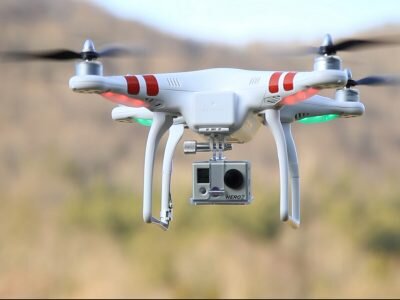
Unmanned Aerial Vehicles (Drones):
Different Types of Drones Used for Photography:
- Quadcopters: Four rotors, highly popular due to their stability and ease of use.
- Hexacopters and Octocopters: More rotors provide greater lift capacity, often used for carrying heavier cameras.
- Fixed-Wing Drones: Resemble mini airplanes; they can cover longer distances but lack the hovering ability.
Advantages of Drone Photography :
- Accessibility: Can access hard-to-reach areas.
- Cost-effective: Compared to hiring a full-sized aircraft.
- Real-time Monitoring: Many drones offer live streaming capabilities.
- Flexibility: Suitable for both video and still photography.
Cameras and Lenses:
Best Cameras for Aerial Photography:
- DSLR and Mirrorless Cameras: High resolution, adaptable with various lenses. Used in professional setups, especially on manned aircraft or heavy-lift drones.
- Integrated Drone Cameras: Come built into many consumer drones. They’re lightweight, capable, and often stabilized with gimbals.
Lenses and Their Applications in Aerial Shots:
- Wide-angle Lenses: Capture expansive views; commonly used in landscape aerial shots.
- Telephoto Lenses: For focused, detailed shots; useful in wildlife or targeted surveillance.
- Fisheye Lenses: For a unique, spherical perspective, though they introduce distortion.
Software:
Post-processing Software:
- Adobe Lightroom and Photoshop: For enhancing colors, correcting distortions, and overall image editing.
- DJI GO: Commonly used for drone photography, offering both shooting and editing functionalities.
Geographic Information Systems (GIS) and Photogrammetry Tools:
- ArcGIS: For mapping and spatial analysis.
- Agisoft Metashape: A popular photogrammetry tool for creating 3D models and topographic maps from aerial images.
As aerial photography continues to evolve, so will the tools and technologies that support it. Whether you’re a hobbyist or a professional, understanding and harnessing these tools can immensely elevate the quality and scope of your aerial shots.
Applications of Aerial Photography:
Aerial photography, with its unique vantage point, has carved out a significant niche in numerous industries. Its ability to capture expansive areas in detail allows professionals across different sectors to gain invaluable insights, make informed decisions, and even showcase beauty from a bird’s-eye view. Here’s a dive into the various applications of aerial photography:
Surveying and Mapping:
Topographical Maps:
Overview: These maps portray the physical features of an area in detail, illustrating landforms like mountains, valleys, and plateaus.
Aerial Advantage: Aerial photographs provide a comprehensive view, aiding cartographers in creating accurate, scaled topographical maps.
Land Use and Land Cover Mapping:
Overview: This involves categorizing and mapping areas based on how land is utilized (e.g., residential, agricultural) and its cover (e.g., forested, wetland).
Aerial Advantage: Large swathes of land can be assessed simultaneously, making it efficient to update and maintain these maps.
Environmental Monitoring and Conservation:
Forest Conservation:
Overview: Monitoring forest health, tracking deforestation, and assessing reforestation efforts.
Aerial Advantage: Allows authorities to detect illegal logging activities, forest fires, and measure the success of conservation initiatives.
Coastal Erosion Studies:
Overview: Observing and predicting the erosion of coastlines due to natural factors or human intervention.
Aerial Advantage: Periodic aerial shots can document changes over time, offering data for predictive analyses.
Urban Planning and Development:
City Layout Planning:
Overview: Designing and strategizing the growth and organization of urban areas.
Aerial Advantage: Offers city planners a holistic view, aiding in optimal land utilization and connectivity designs.
Infrastructure Development:
Overview: Planning and monitoring the construction of roads, bridges, airports, and other critical infrastructure.
Aerial Advantage: Site assessments become more efficient, and progress tracking becomes systematic with regular aerial shots.
Agriculture:
Crop Health Monitoring:
Overview: Assessing crops for diseases, pest infestations, or other issues that could affect yield.
Aerial Advantage: Drones equipped with multispectral cameras can detect health issues invisible to the naked eye.
Precision Agriculture:
Overview: Using technology to optimize crop yields and soil health.
Aerial Advantage: Drones can provide data on soil moisture, crop density, and more, allowing farmers to apply resources precisely where needed.
Real Estate and Advertising:
Property Showcasing:
Overview: Displaying properties, especially large estates or those with unique landscapes, to potential buyers.
Aerial Advantage: Gives a comprehensive view of the property, highlighting amenities and the surrounding environment.
Archaeological Feature Mapping:
Overview: Mapping ancient ruins, buried structures, and other archaeological features to understand historical civilizations, their settlements, and activities.
Aerial Advantage: Aerial photography, especially with the application of remote sensing techniques, can reveal ground patterns and features not easily discernible at ground level. These overhead images can lead to the discovery of previously unknown archaeological sites, such as ancient pathways, burial grounds, or settlement patterns.
Infrared and multispectral imaging can further help in identifying variations in vegetation or soil that might indicate buried artifacts or structures.
Commercial Advertisements:
Overview: Brands using aerial shots or satellite data to create compelling advertisements for products or services.
Aerial Advantage: Adds a cinematic quality to commercials, making them more engaging and memorable for viewers.
Aerial photography’s applications are vast and varied. As technology advances and access to aerial tools becomes more widespread, its influence and utility across industries are poised to grow even further.
Legal and Ethical Considerations:
While the vistas offered by aerial photography are undoubtedly enticing, they come with their own set of legal and ethical challenges. It’s crucial for photographers, whether hobbyists or professionals, to be aware of these considerations, ensuring their craft does not overstep boundaries or cause unintended harm.
Overview of Aviation Laws Related to Drones and Aircraft:
Regulatory Bodies: In many countries, aviation authorities (like the FAA in the U.S., EASA in Europe, or CAAC in China) oversee the safe operation of drones and aircraft.
Licensing and Certification: Depending on the country, drone pilots might need certifications or licenses, especially for commercial purposes or flying in specific zones.
No-fly Zones: Areas near airports, military installations, and certain urban centers are typically designated as no-fly zones.
Height Restrictions: There are often altitude limits set for drones, ensuring they don’t interfere with manned aircraft.
Privacy Concerns and Respect for Property Rights:
Peeping and Intrusion: Drones, due to their maneuverability, can potentially invade private spaces. It’s illegal and unethical to capture images where individuals expect privacy.
Property Overflight: Even if flying over someone’s property isn’t illegal in certain jurisdictions, it’s a good practice to seek permission or notify the landowners.
Best Practices for Ethical Aerial Photography:
Transparency: If flying in a populated area, make your intentions clear to those around. It can allay fears and prevent misunderstandings.
Respect Wildlife: Avoid disturbing wildlife, especially during sensitive times like nesting periods. The noise or presence of a drone can be distressing for animals.
Avoid Sensitive Areas: Stay clear of areas like disaster zones or crime scenes unless you’re authorized. Such scenes might have ongoing operations or could be emotionally distressing for those affected.
Data Protection: If capturing images that might identify individuals, ensure you handle and store that data responsibly, complying with data protection laws.
Stay Updated: Laws and regulations around aerial photography can evolve. Regularly check for updates and adhere to any new guidelines.
Cultural Sensitivity: Be aware of cultural norms and sacred sites. What might be permissible in one culture or region could be seen as disrespectful in another.
Tips and Techniques for Capturing Stunning Aerial Shots:
Aerial photography is a captivating art form that offers a fresh perspective on the world below. However, capturing those dreamy, high-altitude shots requires a blend of technical know-how and artistic vision. Here are some crucial tips and techniques to help you elevate your aerial imagery:
Time of Day and Lighting Considerations:
Golden Hours: Just after sunrise and just before sunset, the light is soft, warm, and diffused. These ‘golden black and white’ hours’ can add depth, dramatic shadows, and a painterly quality to your images.
Avoid Midday Sun: When the sun is directly overhead, it can result in harsh shadows and overexposed landscapes. Unless you’re aiming for a specific effect, it’s often best to avoid this timeframe.
Cloud Cover: A partially cloudy day can add dynamic textures to your aerial shots. Shadows from clouds can create interesting patterns on the ground, while the clouds themselves can be a compelling element.
Camera Settings and Techniques:
Use a Fast Shutter Speed: This helps freeze motion, ensuring that your images are sharp, especially if there’s any movement in the drone or aircraft.
Low ISO: To get the cleanest shots free from noise, especially in daylight, use the lowest ISO setting possible.
Bracketing: Use exposure bracketing to take multiple shots at different exposures. This can be particularly useful for post-processing, allowing you to create a balanced image or an HDR composite.
Raw Format: If your camera allows, shoot in RAW. This format captures more detail and offers greater flexibility during post-processing.
Compositional Tips:
Rule of Thirds: Imagine lens focal length of your frame divided into nine equal sections by two horizontal and two vertical lines. Placing elements of interest along these lines or at their intersections can create a more balanced and engaging shot.
Leading Lines: Roads, rivers, coastlines, and other linear features can guide the viewer’s eye through the image, creating a sense of depth and movement.
Play with Scale: Use known objects (like cars or people) to provide a sense of scale in vast landscapes.
Patterns and Textures: Fields, urban grids, and natural formations can offer mesmerizing repetitive patterns or textures. Look for these abstract visuals that can only be appreciated from above.
Frame Within a Frame: Use elements like a river bend, a ring of mountains, or an urban skyline to ‘frame’ a photo distance a central subject, drawing the viewer’s attention to it.
Incorporating these tips and techniques into your aerial photography ventures will not only improve the technical quality of your shots but also the visual impact they have on viewers. Like any art form, practice is key. The more you fly and shoot, the more refined and instinctual your aerial photography skills will become.
Wrapping Up
Aerial photography is far more than just capturing images from the skies. As we’ve journeyed through its historical significance, methodologies, equipment, and applications, we’ve unraveled its vast influence on diverse fields from cartography to marketing.
So now you’re beginning to see exactly what aerial photography really is. It’s not merely a contemporary fascination; it’s a discipline deeply embedded in our history. It’s a powerful tool for surveying, military defense, marketing, and property maintenance. This art form has offered us, time and again, a unique perspective—literally giving us a bird’s eye view of our world. With the advent of modern technology, its scope has expanded exponentially. Innovations such as WiFi, FPV (first person view), and advanced camera tech equip us to procure sharper, clearer images with a swift turnaround, making the once complex more accessible.
This endless horizon of possibilities lured me into the magnetic world of aerial photography. Today, as I merge my Remote Pilot Certification with my passion for photography, I strive to offer aerial visuals that can accentuate features—be it your property, yacht , or any project. Think about it: if you haven’t yet embraced this vantage point, maybe it’s time you considered integrating professionally curated aerial photographs and videos into your promotional tactics.
The efficiency of national aerial photography program is unmatched. Imagine obtaining the exact visuals you envision, all while adhering to your tight schedule—with the bonus of not even being physically present at the shoot. Whether you’re looking to augment a colossal project or a personal endeavor, there’s room for the transformative touch of aerial photography. If you’re seeking precision, creativity, and a fresh lens to view the world, remember JR Resolutions is here to elevate your perspective.


")


